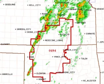
A cold front moving through Kansas brought strong to severe thunderstorms to south central and eastern areas of the state.
Severe thunderstorm warnings were issued for parts of Kiowa, Comanche, Pratt and Barber counties as a line of storms began developing with quarter sized hail and 60 mile-an-hour winds. The storms moved rapidly northeast into Reno, Kingman, Harvey and parts of Sedgwick, McPherson and Marion counties with radar indicating a possibility of ping-pong-ball sized hail. There were no immediate reports of damage.
A tornado watch was issued for much of south central Kansas until 9 p.m. and the watch area includes, Sedgwick, Reno, Kingman, Harper, Harvey, Sumner, Barber, Cowley, Marion, Chase, Pratt and Barber counties.
More widespread rainfall is expected in Kansas this weekend.
[ image – National Weather Service ]


