
A winter storm is expected to bring moderate to heavy snow across Kansas late Tuesday into Wednesday.
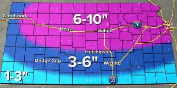
KFDI’s weather partners at KWCH, Storm Team 12, say the snow will begin in the evening and continue into the first half of Wednesday. Snowfall amounts are expected to total 3 to 6 inches for southern Kansas, including the Wichita area. The southern tier of counties along the Oklahoma border could see one to three inches. Northern and central parts of Kansas are expecting 6 to 10 inches of accumulation.
The National Weather Service said a Winter Weather Advisory will be in effect Tuesday evening through Wednesday afternoon for southern areas of Kansas, including Sedgwick, Kingman, Reno, Harvey, Butler, Harper, Sumner, Cowley and Greenwood counties. A Winter Storm Warning is in effect from 6 Tuesday evening until 6 Wednesday evening for central and northern Kansas, including Rice, McPherson, Saline, Marion and Chase counties.
Kansas Governor Laura Kelly has issued a verbal state of disaster emergency proclamation because of the winter storm. The declaration will allow state resources to be used to provide assistance, and there will be a waiver of hours of service for propane providers. The Kansas Division of Emergency Management will be monitoring the situation and will assist counties and local responders if requested.
Bitter cold temperatures will return during the week with highs in the 20s for Wichita Wednesday and Thursday. Wind chills will be the coldest on Thursday with values from 5 to 15 degrees below zero.
[ map: KWCH ]


